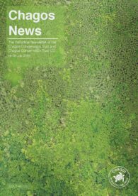
A comprehensive task
In 2018, Sara Bárrios and Tim Wilkinson, a botanist and a spatial scientist from the Science Department of the Royal Botanic Gardens Kew, travelled to the island of Diego Garcia with the aim of creating the first comprehensive record of the island’s vegetation.
Once known for its coconut plantations, the vegetation of Diego Garcia is now a complex mix of abandoned plantation sites gone wild, and areas where native plant species still dominate.

A blooming success
Prior to this field trip only very limited plant survey data was available. Now, having used a suite of different survey techniques, the team surveyed the whole island and its various habitats.
Expedition key aims
Recording vegetation every mile by dividing the islands into areas, using a traditional survey approach. This botanical data is available online via Kew’s Online Herbarium.
Experimenting with capturing survey points with 360° photos. Annotated habitat images were recorded using a 360° camera. The plant survey dataset collected will now be used to guide and validate the mapping of Diego Garcia’s vegetation.
Collecting images from a drone that surveyed a representative area of the island vegetation. For each flight the set of images have yielded high quality image maps, orthomosaics, and complementary photogrammetrically-derived digital surface models.
Collecting the first seeds from Diego Garcia that have been processed and added to Kew’s Millennium Seed Bank, and several fungi which have been incorporated in Kew’s Fungarium.
The full report can be read here.
A members’ talk on the ‘Plants of the Chagos Archipelago’ by Trustee and Royal Botanic Gardens Kew’s Dr Colin Clubbe was held on 30 October 2025 and is available to watch on the Trust’s YouTube channel below.