New satellite vegetation maps available
17th October 2018
As part of CCT’s Darwin Initiative’s Darwin Plus project RBG Kew’s GIS team have produced a set of vegetation maps using satellite imagery, expert input and available plant location data to provide a baseline for future conservation actions, particularly the terrestrial rehabilitation of the Chagos Archipelago.


The new maps can be found on the Chagos Information Portal, a reference library of a science, research and conservation work conducted in the Chagos Archipelago.
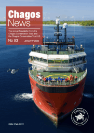
This year's issue of Chagos News is out! And it's packed with articles about the latest conservation research and work happening in the Chagos Archipelago
Read the story
This year’s Chagos Conservation Trust festive e-card was sent to our members last week – you can view it here.
It features a stunning picture of a Chagos green turtle drawn by our...
Read the story
The Chagos Conservation Trust has been successful with its Darwin Plus Main and Local Programme applications, being awarded nearly £1million to undertake three Healthy Islands, Healthy Reefs (HIHR) nature restoration projects in the northern atolls – and largest island, ...
Read the story