BIOT Science Expedition 2014 - Dr John Turner Initial Report
Video Archive for Long Term Monitoring of Coral Reef Benthic Communities:
John Turner and Ronan Roche, School of Ocean Sciences, Bangor University, UK.
During the 2014 Expedition, John Turner and Ronan Roche continued to develop an archive of video of coral reef benthic community structure across depths at sites throughout the atolls. The aim is to produce a record that can be analysed and compared with video records made at the same sites in 2006, and for comparison in future years.
The reefs of Chagos represent an important reference site because they are remote from human activities that cause impacts, such as overnutrification, resource extraction and habitat modification. However, they are exposed to impacts caused by change in climate such as ocean warming, storms and ocean acidification. The reefs provide a bench mark for observing the effect of changing conditions in the absence of direct human impact, and indicate how relatively intact and functional reef communities respond to these conditions. Previous studies have shown that benthic cover, especially of hard corals, reduced following bleaching related mortality after warming events in 1997, 2003 and 2005 but that Acropora corals re-established across the shallow reef slopes and terraces. Although benthic cover measurements were made on the first expeditions in the 1970s, photography and video techniques were limited, and it is difficult to compare the state of today’s reef communities with those of the past. However recent investigations have shown that visual surveys and video surveys provide comparable measures of cover, and therefore a video archive can provide important data for assessing change. Video recording has a number of advantages over traditional survey techniques; the main advantage being that a relatively large tract of reef can be recorded during one dive and imagery can be then be analysed in the laboratory without the constraints imposed on an observer underwater. Because many randomly grabbed frames (equivalent to sampling from quadrats) can be assessed from video, the sites need only be approximately located because sampling is representative of the reefs.
The project tests the hypothesis that the reefs of Chagos are highly resilient because they are functionally and structurally intact, and that the reef communities are returning to pre bleaching levels of cover and development. In addition, the video archive will be used in collaborative work with other expedition teams, for example to test the hypothesis that no diseased corals were present in 2006, but are now evident on all reefs. Diversity and abundance of grouper and other large reef fish species were recorded on the same reefs by the fish team, and the video data will be used to assess topography/rugosity as a measure of complex reef habitat for fish. The seaward and lagoon sites at Salomon, Peros Banhos, Great Chagos Bank (including Nelson, The Brothers, Eagle, Danger Island), Egmont and Diego Garcia were surveyed, most of which were first recorded using video in 2006. Some new sites were added (e.g. at Blenheim – a submerged atoll) for future comparisons. Accurate site identification has previously been confounded by poor position fixing (probably due to inferior GPS technology in 2006; user-error in ensuring best satellite configuration and possibly transfer errors in recording positions), and therefore a database of monitoring sites was established by carefully recording site positions using a high specification Garmin Montana GPS with built in camera to record the nearest land feature where appropriate.
Ten minute sequences of video were recorded across 5 m depth intervals from 25 m depth to 5 m depth using a Sony HDR 550 video camera in a Light and Motion Blue Fin housing equipped with a Fathom 90 wide angle port lens and Sola 1200 lumen video lights (figure 1).

Figure 1: John Turner with underwater video camera equipped with wide angle lens, LED lights and red lasers. A Go Pro camera mounted on top of the video housing recorded habitat scale images at 30 second intervals
Scale was provided by two red lasers which projected red dots 10 cm apart on the video image. Approximately 80 wide angle habitat images were recorded randomly on each dive by a Go Pro Hero 3 camera with red filter and set to record high definition images at 30 second intervals. In addition, close up digital photographs were recorded to ‘truth’ the video, and observations of reef topography and large scale rugosity were recorded (see report by Ronan Roche).
Twenty four sites were surveyed in 2014, accounting for over 55 hours underwater and 24 hrs of video records, 2200 Go Pro habitat images and about 2000 truthing images. 15 of these sites were visited in 2006, 12 in 2013 and 8 sites were new to the archive. It is anticipated that the sites surveyed during the 2013- 2015 expeditions will duplicate all survey sites recorded in 2006.
Video sequences from four 5 m depth intervals (5-10 m, 10-15m, 15-20m and 20-25m) from a sub group of sites will be compared between 2013 and 2014, but most emphasis will be placed on comparing current data with 2006. Fifty frame grabs will now be randomly taken from each depth interval at each site using Pinnacle software, and these will be imported into CPCe software (NCRI Florida) and overlaid by 16 randomly generated points. The substrate, benthic life form, and where appropriate genus and species underlying each point are then automatically collated in an Excel spreadsheet using tab keys in CPCe, and the spreadsheet data is then imported into statistical software for analysis. Frame grabs can be moved frame by frame to assist in identification, and the ‘truthing’ images will be used to identify species where video image resolution is insufficient. The Go-Pro images will provide reef descriptions and context, especially for reef fish habitat. In a separate analysis, every video sequence will be run and presence of diseased coral will be recorded, with extent in colony and size of colony assessed.
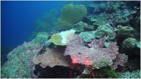
Figure 2: A video frame in which live and dead coral is evident, including some Acropora tables showing signs of disease, and dead standing tables close to collapse. The red laser dots provide a scale of 10cm in the foreground of the image.
A preliminary review of the video archive shows that Acropora coral colonies are now less abundant on most reef terraces throughout the atolls, and many of those remaining display signs of disease or have died. At present, we do not know whether these corals have perished due to old age, bleaching, disease or storms, or a combination of these factors. Even dead standing Acropora tables appear to have been removed from exposed reefs, probably being swept off the steep slopes by storms. This reduction in reef structure and habitat may have an effect on the reef fish communities. On some reefs it is evident that small and diverse corals are replacing the Acropora tables, and it is probable that these will develop into a new and more diverse community with time. Of concern is that some of these corals also display symptoms of disease. Recruits were observed on dead standing corals, but many of these will be lost when the dead coral framework collapses. Last year, there was very high mortality in corals below 15 m in Salomon atoll lagoon, probably due to a warming event which caused warm dense seawater to sink in this relatively enclosed atoll, and to kill deeper corals. However, some recovery was evident in corals below 15 m depth this year, which may be an indication of resilience and is an encouraging signal.

Figure 3: A randomly recorded image from the Go-Pro camera to illustrate reef slope community structure which will be used to provide context for fish habitat descriptions.